ArticlesNo Comments

It is a system that provides geo-spatial positioning. For this it uses a system of satellites and electronic receivers to determine location in terms of longitude, latitude, and elevation to a high precision, using time signals that are transmitted from satellites. These signals can also be used by electronic receivers to calculate the current local time to a high precision, using time signals that are transmitted from satellites. These signals can also be used by electronic receivers to calculate the current local time to a high precision.
Satellite navigation can be used for regional or global coverage, is achieved by the constellation of satellites. The electronic receiver is small enough to be incorporated into the electronics of a vehicle or a mobile phone. The satellite navigation system can be used to avoid traffic jams in cities, find the nearest free parking space, restaurants, hotels, shops in any unfamiliar city.
To find the location of a point, there is a requirement of a minimum of two satellites. Distance from each of the satellites is determined by measuring the time taken by the signal to travel from satellite to the receiver. The distance measurement finds two locations on a circle where two spheres intersect. Radius of the sphere is the distance between the satellite and receiver on the surface of the earth, the position is the point where the Earth’s surface touches the circle.
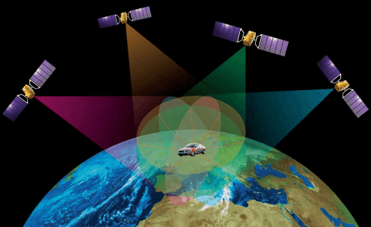
For the synchronization of time with the electronic receiver’s clock and satellite clock, a third satellite is required. To find the position of a point or object above the Earth’s surface a fourth satellite is required. Therefore, to get the location of a point on the surface of the Earth and above it, three or four satellite is the minimum requirement. Satellites use atomic clocks that are continuously synchronized with a master clock on the ground.
There is a requirement of high positioning accuracy to monitor the precise location of satellite for this purpose there is a network of reference stations on the ground. There are errors that degrade the accuracy of positioning ionosphere, an electrically charged outer layer of the atmosphere, which can slow down the signal. Signal can take an unusually long path if it is reflected off by tall buildings and other structures before received by the receiver. There is also clock errors and numerical calculations.
Global navigation satellite systems
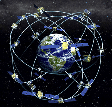
GPS: Global positioning system consists of 32 satellites orbiting in medium earth orbit in six different orbital planes.
GLONASS: GLONASS is Global Navigation Satellite System, has a constellation of 24 satellites, and has a global coverage.
GALILEO: It consists of 30 Medium Earth Orbit Satellites and is expected to be in full service in 2020.
NaVIC: It is Navigation with Indian Constellation. It consists of a constellation of 7 navigational satellites of which 3 are placed on the Geostationary orbit and 4 in Geosynchronous orbit.
Be the first to post a comment.